Developments in 2015 (part 1)
As we are in early 2016, the moment is good for practising a little exercise on "balance and perspectives". Let us start with a retrospective of developments in 2015 in the user interface:
- Mapping flow data
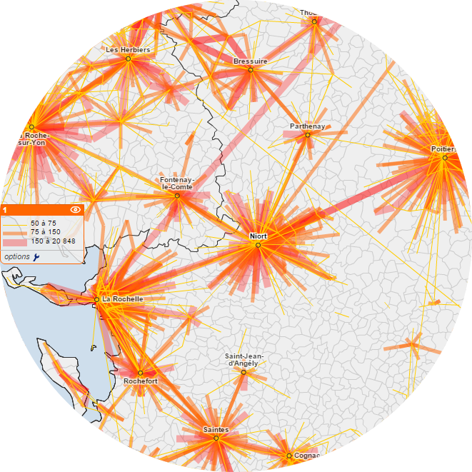 With Géoclip, each indicator is mapped according to a suitable representation mode, essentially choropleth or proportional circle analyses. However, certain indicators require specific representation modes. This is the case with flow data.
A new representation mode enables users to display phenomena of attraction (a line connects each object on the map to its hub), as well as the intensity of these phenomena reflected by the thickness of the line. This representation mode is used, for example, for mapping commutes from home to work, or from home to school.
- Desynchronising the framing of two adjacent maps
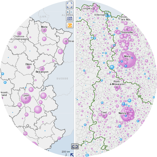 With Géoclip, you can display two maps side by side, in order to compare different regions with each other. Each map can represent different indicators, for different geographical levels. On the other hand, by default, the framing of both maps is synchronised: a zoom or a movement on one map is automatically reflected on the other map. A new button has been introduced, on the margin between the two maps, in order to desynchronise the framing. It is thus possible to compare two regions, or alternatively to obtain a general view on one map and zoom into a more limited region on the other.
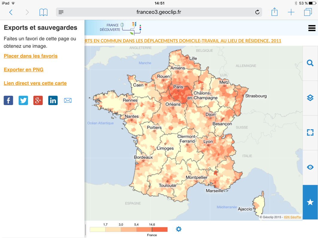
- Exporting maps in vector form
 With Géoclip, all maps can be printed or exported. Two export formats are available: pdf or image. The first produces a standard file, which is sufficient in itself. The second cialis e igual ao viagra enables you to integrate the map in another document. Two possibilities are now offered for exporting images: either a bitmap image in jpeg format, or a vector image in svg format.
The advantage of the vector format is that it preserves the quality of the image when it is enlarged or reduced. This should satisfy all graphic designers, modellers, desktop publishers and other players in the vast world of communication..
- Exporting data from reports
 With Géoclip, the mapped data can be exported to a spreadsheet file, in xls format. This data export function is now also available for reports or portraits of regions. An «Export to Spreadsheet» button has been added to the toolbar at the top of each report page. The user clicks on this button to download an xls file containing all the data needed for preparing tables and generic levitra canada graphs for the report. Each page of the report corresponds to a different tab in the xls file. Complete labels and the sources of the indicators are also given.
- Adding customised labels
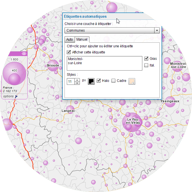 With Géoclip, users can customise their map to make it more readable. To add reference points, in addition to or instead of those provided by default, users can add labels indicating the name of certain geographical objects. As this concerns cosmetic attributes of the map, the Labels panel is displayed from the View menu. The labels are placed with a Ctrl+ click on the map. In addition to the position, you can modify the text and adjust the size and colour of the characters, as well as their formatting attributes such as bold, italic, outline or frame.
- Locating a postal address
 With Géoclip, the user can search for a place by indicating its name or just a few letters of the name, and obtain a list of geographical objects.
To make this search tool even more specific, it is possible to indicate a postal address. This address is analysed, geolocalised and marked on the map by a flashing dot, and the map zoom is automatically centred on this dot. This function is useful for observatories focusing on regions on a large scale, for example a large city, with small geographical objects, for example census districts.
- Supplementing the features of the mobile interface
Designing Géoclip for small touch screens meant that the interface had to be adapted, refined and simplified. Certain complex features of the desktop version have therefore been fully reviewed, such as the publishing of reports. Others are not accessible on the mobile version, such as the importing of personal data.
However, one function seemed patently obvious for tablets or smartphones: sharing on social networks! This enables you to post a configured link to a map directly on Facebook, Twitter, Google+ or LinkedIn.
Another addition to the mobile version concerns parameterizing of thematic analyses, in order to choose your colour palette and discretisation method, like on your computer.